The importance of a maritime connection and the discouraging results of the efforts to discover a natural channel between the two oceans suggested to many minds the idea of a ship canal. Nicaragua, Panama, and Darien were regarded as early favorable locations for canal routes because of relatively short distances across the isthmus and good harbors.
The Isthmian Canal Commission was appointed, June 10, 1899, to investigate the most practical route for an interoceanic canal under U.S. ownership and control. They surveyed routes through Nicaragua, Panama, and the Isthmus of Darien. Initially (November 1901) the Commission recommended the Nicaraguan route. In December 1901, after the Compagnie Nouvelle du Canal de Panama offered to sell its assets and rights to the United States for $40 million, they issued a supplemental report recommending the adoption of the Panama route.
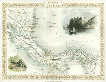
J. Rapkin
Isthmus of Panama from Tallis’ The Illustrated Atlas, and Modern History of the World. 1854. 10.63 in. x 13.78 in.
G4872.P2 1854.R3 CARTA Map & Imagery Library, George A. Smathers Libraries. Gift of the Panama Canal Museum.
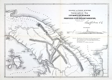
Lionel Gisborne
Topographical map of a portion of the Isthmus of Darien: in site of proposed inter-oceanic navigation, August 1852 from Author Message from the president of the United States to the two houses of Congress at the commencement of the 2nd session of the 33rd
Congress. 1854. 13.78 in. x 19.3 in. on sheet 15.75 in. x 21.25 in.
G4872.P2 1854.G5 CARTA Map & Imagery Library, George A. Smathers Libraries.
Isthmian Canal Commission
Nicaragua Route, Parts of Nicaragua and Costa Rica
Showing the Line of the Proposed Nicaragua Canal
from Report of the Isthmian Canal Commission,
1899-1901. 1901. Map & Imagery Library, George A. Smathers Libraries. Gift of the Panama Canal Museum.
Lake Nicaragua is the main advantage of the Nicaragua route, as is the close proximity of the Pacific Ocean. However, there were difficulties securing an agreement with the political powers of the region and extensive work had to be done to create a canal from the Atlantic to the Pacific.
Isthmian Canal Commission
Panama Route, Map Showing Location of Proposed
Canal from Report of the Isthmian Canal Commission,
1899-1901. 1901. Map & Imagery Library, George A. Smathers Libraries. Gift of the Panama Canal Museum.
The natural attractions of the Panama route lie in the combination of a very narrow isthmus with a low summit. The high portion of the isthmus is a width of about six miles near the Pacific side. The Chagres River affords access by canoe from the Atlantic to within sixteen miles of the Pacific.

This online exhibition is based on the Panama Canal Centennial exhibitions that were organized by the George A. Smathers Libraries to celebrate the centennial of the opening of the Panama Canal. The exhibitions were presented across the University of Florida campus, including the Fisher School of Accounting, Florida Museum of Natural History, Legal Information Center, Samuel P. Harn Museum of Art, and Smathers Libraries. All items are part of the Panama Canal Museum Collection, Special & Area Studies Collections, George A. Smathers Libraries, University of Florida unless otherwise noted.
View the complete object lists from the centennial exhibitions

The importance of a maritime connection and the discouraging results of the efforts to discover a natural channel between the two oceans suggested to many minds the idea of a ship canal. Nicaragua, Panama, and Darien were regarded as early favorable locations for canal routes because of relatively short distances across the isthmus and good harbors.
The Isthmian Canal Commission was appointed, June 10, 1899, to investigate the most practical route for an interoceanic canal under U.S. ownership and control. They surveyed routes through Nicaragua, Panama, and the Isthmus of Darien. Initially (November 1901) the Commission recommended the Nicaraguan route. In December 1901, after the Compagnie Nouvelle du Canal de Panama offered to sell its assets and rights to the United States for $40 million, they issued a supplemental report recommending the adoption of the Panama route.
J. Rapkin
Isthmus of Panama from Tallis’ The Illustrated Atlas, and Modern History of the World. 1854. 10.63 in. x 13.78 in.
G4872.P2 1854.R3 CARTA Map & Imagery Library, George A. Smathers Libraries. Gift of the Panama Canal Museum.
Lionel Gisborne
Topographical map of a portion of the Isthmus of Darien: in site of proposed inter-oceanic navigation, August 1852 from Author Message from the president of the United States to the two houses of Congress at the commencement of the 2nd session of the 33rd
Congress. 1854. 13.78 in. x 19.3 in. on sheet 15.75 in. x 21.25 in.
G4872.P2 1854.G5 CARTA Map & Imagery Library, George A. Smathers Libraries.
Isthmian Canal Commission
Nicaragua Route, Parts of Nicaragua and Costa Rica
Showing the Line of the Proposed Nicaragua Canal
from Report of the Isthmian Canal Commission,
1899-1901. 1901. Map & Imagery Library, George A. Smathers Libraries. Gift of the Panama Canal Museum.
Lake Nicaragua is the main advantage of the Nicaragua route, as is the close proximity of the Pacific Ocean. However, there were difficulties securing an agreement with the political powers of the region and extensive work had to be done to create a canal from the Atlantic to the Pacific.
Isthmian Canal Commission
Panama Route, Map Showing Location of Proposed
Canal from Report of the Isthmian Canal Commission,
1899-1901. 1901. Map & Imagery Library, George A. Smathers Libraries. Gift of the Panama Canal Museum.
The natural attractions of the Panama route lie in the combination of a very narrow isthmus with a low summit. The high portion of the isthmus is a width of about six miles near the Pacific side. The Chagres River affords access by canoe from the Atlantic to within sixteen miles of the Pacific.
This online exhibition is based on the Panama Canal Centennial exhibitions that were organized by the George A. Smathers Libraries to celebrate the centennial of the opening of the Panama Canal. The exhibitions were presented across the University of Florida campus, including the Fisher School of Accounting, Florida Museum of Natural History, Legal Information Center, Samuel P. Harn Museum of Art, and Smathers Libraries. All items are part of the Panama Canal Museum Collection, Special & Area Studies Collections, George A. Smathers Libraries, University of Florida unless otherwise noted.
View the complete object lists from the centennial exhibitions