

The early maps of Jerusalem epitomize the combination of artistic interpretation with scientific reality wherein imagined biblical scenes are placed unapologetically alongside actual geographical landscapes.
The centrality of Jerusalem to the Bible meant that cartographers were compelled to map out the city long before modern cartographic techniques were developed.
Following the invention of printing, maps began to be printed towards the end of the 15th century. The first method employed was woodcuts: images were copied in reverse onto a wooden block, then the non-printed areas carved away. The block was then inked and a letterpress, which could also print typeset text on the map, transferred the ink to paper using direct pressure. Later mapmakers used incised copper plates, which were inked and put through rollers along with a sheet of paper. By the mid-16th century, copperplate engraving gained dominance over the woodcut method, because it allowed for finer detail work and easier revision. Some maps were hand-colored after they were printed.
Part of the popular 15th century work, Liber cronicarum, commonly called the Nuremberg Chronicle, this map represents the first imaginary view of Jerusalem in print. Jerusalem is represented as a circle with Solomon’s Temple, identified as Teplum Salomois, at the center. Contrary to the biblical description, the temple is depicted as a building with three domes, resembling a typical Byzantine church with basilica. The compact city layout recalls the image of medieval German castles. Schedel’s bird’s-eye view simulates the elevated profile of this holy city.
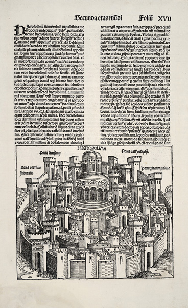
Hierosolima From Liber cronicarum
Nuremberg
1493
Woodcut
18.9 x 22.3 cm., on sheet 45.6 x 31.6 cm.
G7504.J4 1493 .S3 CARTA
From the Map & Imagery Library, Holy Land Map Collection
Gift of Dr. James C. and Adina P. Simmons in memory of their parents

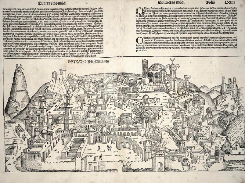
Destruccio Iherosolime From Liber cronicarum
Nuremberg
1493
Woodcut
G7504.J4 1493 .S31 CARTA
From the Map & Imagery Library, Holy Land Map Collection
Also from Liber cronicarum, this map shows a composite view of the many destructions of Jerusalem in ancient times. Broken buildings litter the landscape and Tempu Salomois (Solomon’s Temple) is shown on fire. The Temple is again depicted as a domed building with a crescent moon on top, perhaps to represent the Dome of the Rock, or perhaps as a symbol of Byzantium, since the crescent moon was only adopted more widely by the Muslims under Ottoman rule beginning in 1453 CE. Another notable feature is the open porta aurea, the Golden Gate, which was later sealed by the Ottomans in 1541 CE.