

Titus Flavius Josephus, born in Jerusalem in 37 CE, was a Jewish Roman historian whose works are considered a major source for early Jewish history, particularly with regard to the Jewish Roman Wars in the first century CE.
Josephus fought against the Romans and led the Jewish forces in Galilee during the first Jewish-Roman War (66-73 CE). He surrendered in 67 CE to Vespasian’s army. In captivity, Josephus told Vespasian that Jewish Messianic prophecies had made reference to Vespasian becoming Emperor of Rome. Josephus was kept as an interpreter and granted freedom after Vespasian became emperor two years later in 69 CE. In gratitude Josephus adopted the emperor’s family name Flavius.
Flavius Josephus defected to the Roman side and was granted Roman citizenship. He became an advisor and translator for Vespasian’s son Titus during the Siege of Jerusalem in 70 CE. Given his strategic position, Josephus’ writings provide important eye witness accounts of events in Jerusalem during the first century CE. However, the imperial patronage of Josephus’ work means that doubts are cast as to the extent to which he produced impartial histories and speculation is raised as to the degree to which his accounts were the imaginings of the victor.
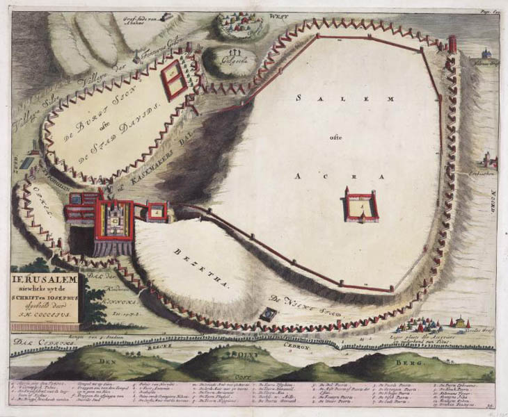
Ierusalem niewlicks uyt de Schriften Iosephus
From Alle de Werken
Amsterdam
1722
Copper engraving
33 x 40 cm., on sheet 35 x 45 cm.
G7504.J4 1722. C6 CARTA
From the Map & Imagery Library, Holy Land Map Collection
Gift of Dr. James C. and Adina P. Simmons in memory of their parents
An imaginary view of ancient Jerusalem based on the The Jewish War by Josephus. The map shows locations significant to The Jewish War which described the Roman Jewish War of 66-73 CE. The left foreground shows a detailed drawing of Solomon’s Temple on Mount Moriah, “a. Moria met den TEMPL.” Fort Antonia, “h.’t Fort Antonia,” named after Marc Antony by Herod, and the Palace of Queen Helena, “k. Paleis vande Coninginne Helena” are both depicted on the map. Other details from The Jewish War include the siege wall built by Titus around Jerusalem, and the Roman encampment at ‘The Camp of the Assyrians’ (bottom right on map) which was out of bow shooting range.

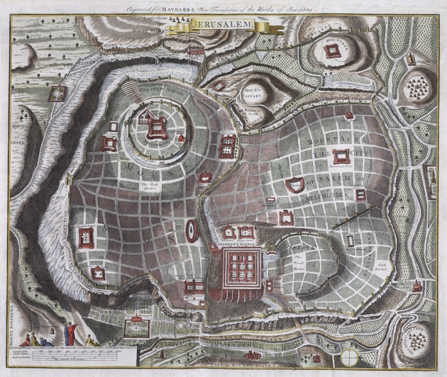
Jerusalem From G.H. Maynard,Josephus’ whole genuine and complete works
[London, ca. 1792]
Copper engraving
35 x 43 cm., on sheet 40 x 52 cm.
G7504.J4A3 17-- .J4 CARTA
From the Map & Imagery Library, Holy Land Map Collection
Another imaginary view of Josephus’s Jerusalem as presented in the “The Whole, Genuine and Complete works of Flavius Josephus,” in the London edition from c. 1792. A note in the top margin of the map reads “Engraved for Maynard’s new translation of the works of Josephus.” The map includes buildings of biblical and historical significance, such as Solomon’s Temple, the City of David, Herod’s House, and Pilates House as well as Pompey’s encampment on the outskirts of the city. A scale in the bottom left of the map converts sacred cubits to ancient and modern stadias as well as the Italian half-league.