


Jerusalem from the east is this city’s most iconic viewpoint. It is a view found often in maps, drawings and illustrations and even in modern photographs. Looking down and over at Jerusalem from the Mount of Olives in the east provides the best vantage point as it is higher than the city itself.
For Judaism, the Mount of Olives has long been a point of pilgrimage, affording a view of the site of the destroyed Temple and a place for lamentation. It is also the site of the oldest Jewish cemetery in the world; a place to which the Messiah will come and the dead will be resurrected. For Islam, the Mount of Olives is a site of pilgrimage too; the east affords the best view of the Dome of the Rock, and the city’s eastern wall is believed to be the area where Allah will make his final judgment.
This city viewpoint, however, was particularly popular among the early Christian cartographers and illustrators who realized that the view from the east would have been often contemplated by Jesus. The Mount of Olives was where Jesus spent much of his time, but especially the last week of his life, and it is the point from which he is believed to have ascended to heaven.
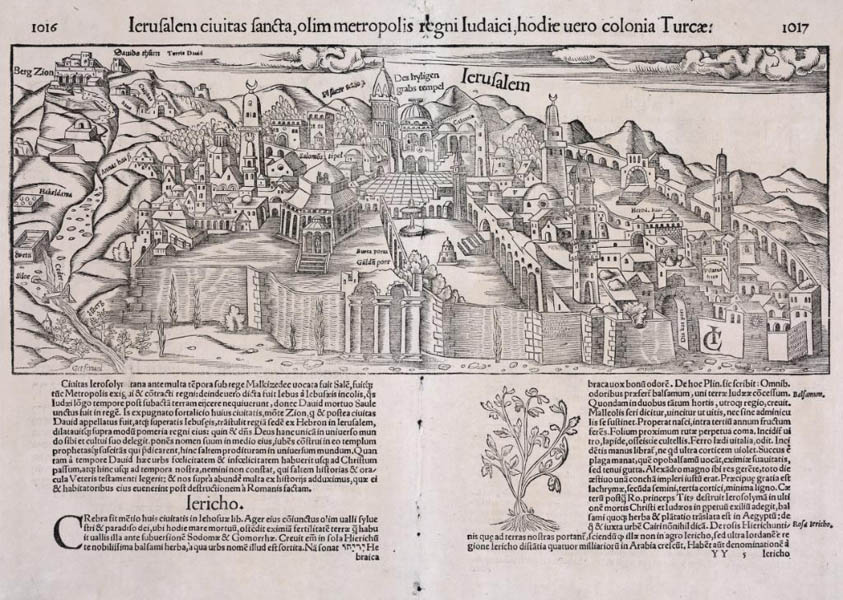
Ierusalem ciuitas sancta, olim metropolis regni Iudaici, hodie uero colonia Turcae
From Cosmographia universalis
Basel
1552
Woodcut
15.1 x 37.5 cm., on sheet 30 x 39.5 cm.
G7504.J4 1552 .M8 CARTA
From the Map & Imagery Library, Holy Land Map Collection
Gift of Dr. James C. and Adina P. Simmons in memory of their parents
A bird’s eye view of Jerusalem to the east, the title translates to “Jerusalem the holy city, formerly the capital of the Kingdom of Judah, today a Turkish colony.” Unlike other maps which depict the biblical Jerusalem, this map shows a contemporary view from the mid-16th century. Place names are given in German and descriptive titles in Latin. The Golden Gate is labeled in both: aurea porta, and gülden port. The Temple Mount is seen from the Mount of Olives. The building where the Dome of the Rock stands is labeled as Solomon’s Temple (Salomos Tepel). Other landmarks of significance to Christianity are also labeled: the Church of the Holy Sepulchre (Das hyligen grabs tempel) can be seen in the upper middle portion of the map and in the distance, Calvary (Caluaria), Mount Zion (Berg Zion) and Gethsemane (Getsemani) are noted. The crescent moon symbol, widely embraced by the nascent Turkish Empire, is seen atop many buildings.

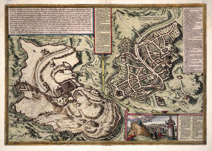
Hierosolyma, clarissima totius orientis ciuitas, Iudaee metropolis
From Civitates orbis terrarum
Cologne
1572
Copper engraving
25.5 x 28.5 cm. and 25.5 x 24 cm., on sheet 37 x 54.3 cm.
G7504.J4 1572. H6 CARTA
From the Map & Imagery Library, Holy Land Map Collection
Gift of Dr. James C. and Adina P. Simmons in memory of their parents
Another map from Civitates orbis terrarum, this portrayal shows Jerusalem during ancient times on the left (“Descriptio antiquae vrbis Hierosolymorum”) and during the modern period (16th century) on the right (“Noua vrbis Hierosolymianae descripio”). The gates are labeled with double letters AA thru HH and described in the center box. Other locations are represented by both numbers and single letters. A small inset on the lower right shows Moses receiving the Tablets of the Law with the vestments of the priest labeled. The Dome of the Rock with a crescent moon is depicted in the section showing the modern view of Jerusalem under the Ottoman Empire. The walls surrounding the Dome of the Rock are labeled with the letter A and indexed as the site of Solomon’s Temple.
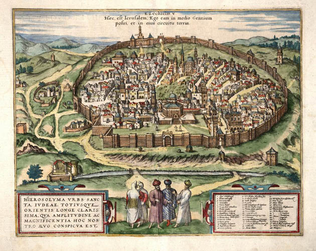
Hierosolyma urbs sancta, Judeae, totius que orientis longe clarissima, qua amplitudine ac magnificentia hoc nostro aevo conspicua est
From Civitates orbis terrarum
Cologne
1575
Copper engraving
32.7 x 41.3 cm., on sheet 40.5 x 54 cm.
G7504.J4 1575 .H6 CARTA
From the Map & Imagery Library, Holy Land Map Collection
Gift of Dr. James C. and Adina P. Simmons in memory of their parents
Another view from the east, the title of this map is “Jerusalem, the Holy City, by far the most famous city of Juda and the East, in her present time size and greatness.” At the top is a quote from Ezekiel 5:5: “This is Jerusalem! I have set her in the midst of the nations, and countries are round about her.” The buildings and locations on the map are numbered and a key index is provided in the lower right hand corner. The Dome of the Rock is again identified as Solomon’s Temple: a tradition dating back to the Crusader period. The Golden Gate (13. Porta aurea) is shown as sealed: Suleiman the Magnificent had sealed the gate in 1541 just 36 years before this map was created. At the forefront of the map are figures dressed in Ottoman style clothing.
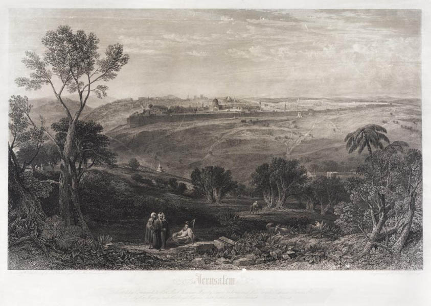
Jerusalem: From the Mount of Olives
Glasgow
1841
Steel engraving
36 x 57 cm., on sheet 45 x 62 cm.
G7504.J4A35 1841 .L4 CARTA
From the Map & Imagery Library, Holy Land Map Collection
This depiction of Jerusalem from afar is “dedicated by command to Her Most Gracious Majesty Queen Victoria and His Royal Highness Prince Albert, by Her Majesty’s and His Royal Highness’ most faithful humble servant William Forrest.” A popular viewpoint for the city of Jerusalem: the Mount of Olives offers a panoramic view of the Temple Mount. This rendering shows the city walls and buildings of Jerusalem in the distance, with four people and a goat in the foreground; a man on a donkey can be seen nearby. The figures are imagined wearing biblical garb.